Introduction:
Embarking on the journey of purchasing a property is a significant step that demands careful consideration and meticulous planning. Beyond the realm of legal verifications lies a plethora of crucial aspects that can profoundly impact the success and suitability of your project. This comprehensive guide delves into the essential factors that go beyond mere legalities. It offers insights tailored to ensure a well-informed decision-making process. From assessing road types and land acquisitions to scrutinising nearby water bodies and navigating through NOC requirements, each aspect plays a pivotal role in shaping the outcome of your property acquisition endeavour. Join us as we unravel the intricacies of property selection. We will empower you to make informed choices aligned with your specific project requirements and aspirations.
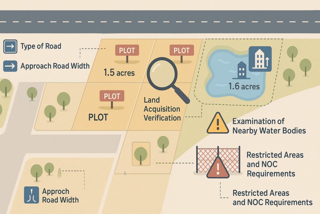
Type of Road:
- Direct Approach with Public Road is always preferable.
- If there’s no direct road approach, ensure the private passage with defined width and they abut a public road.
- Private passage with defied width has its own limitation, will very case to case.
Approach Road Width:
When you are looking for a land for Residential Layout Proposal, you must verify the approach road width based on the location.
- Village Panchayat: Min 6.0m wide road
- Town Panchayat: Min 6.5m wide road
- Municipalities, Peri-urban Panchayats, and Municipal Corporations: Min 7.0m wide road.
If you have Building Proposal:
- Residential building’s up to 8 dwellings with height up to 14.0m or
Stilt + 3Floors or Ground + 2 Floors: Min. 3.0m-6.0m wide road is required
- Approach Road for commercial building 9.0m width is required. However, up to 300 sqm of commercial building is allowed with 6.0m from the road width.
- Residential and commercial buildings up to 18.30m height: Min 9.0m and above, wide roads
- For Industrial / Institutional buildings up to 18.30m height: Min 7.0m
- Theatres and Multi-Story Parking lots – Min 12.0m wide Road
- Community/ Exhibition halls and Kalyanamandapams – Min 15 m wide Road
- Star hotels and Malls – Min 18 m wide road.
- For High Rise Buildings above 18.30m height – Min 12m Wide road.
Land Acquisitions Verification:
Before proceeding with a property purchase for a project, it’s essential to investigate any land acquisitions carried out by the state and central governments of India. Here are key considerations regarding land acquisitions:
- Government Acquisitions: Recognise that both central and state governments in India possess the authority to procure private land for public purposes. This is often for industrialisation and infrastructure development.
- Tamil Nadu Housing Board (TNHB): Investigate any land acquisitions carried out by the TNHB on behalf of the government under Section 4(1) of the Land Acquisition Act, 1894.
- Proposed Scheme Roads and Road Widening: Review detailed development plans at the district level. This will help you to understand proposed scheme roads and road widening projects that may impact the property.
- National and State Highway Road Widening: Be aware of acquisitions related to the widening of national or state highways. This could affect the property’s value and accessibility.
- Airport and Railway Land Acquisitions: Consider possible land acquisitions for airport and railway expansions. Such infrastructural developments can influence the property’s suitability for the intended project.
Land Classifications:
Before finalising a property for your project, it’s crucial to consider land classifications. This helps you ensure that the chosen parcel aligns with your project needs and complies with relevant regulations and restrictions.
- TNCBDR2019 Rules: Familiarise yourself with the Tamil Nadu Combined Development and Building Rules, 2019. Lands are categorised into several classifications, including Residential, Commercial, Industrial, Institutional, Open Space & Recreational (CMA), and Urbanisable/Non-Urbanisable (CMA) zones in Taluks and Corporations in Tamil Nadu. (CMA refers to the Chennai Metropolitan Area.)
- Panchayat and Town Panchayat Lands: In village and town panchayats, there might not be specific land classifications. This offers flexibility for development according to your requirements.
- Agricultural Land Classifications: Agricultural lands are typically classified as Wet and Dry in patta/chitta documents. Dry agricultural lands can be reclassified from one classification to another, while wet agricultural lands have some limitations on conversion.
To know more about Land use Classification and zoning regulations in Tamil Nadu, check this blog.
Examination of Nearby Water Bodies:
Before finalising a property for your project, it’s crucial to assess nearby water bodies. Here’s what you should consider:
- Physical Verification: Conduct a physical inspection to verify the presence and condition of water bodies nearby. This ensures accurate information about their location and potential impact on the property.
- Review Records: Check official records, such as revenue records, to confirm the existence and details of water bodies mentioned. Sometimes, water bodies may be documented in records but not physically present, which could affect road access to the land or result in water passing through the property.
By thoroughly examining nearby water bodies both physically and through records, you can avoid potential complications and ensure the property’s suitability for your project.
Planning Land Size Based on FSI:
When considering a property for your project, it’s essential to plan the land size according to the allowed Floor Space Index (FSI). Here’s what you need to know:
- Understanding FSI: FSI, or Floor Space Index, determines the maximum building construction allowed on a piece of land. Typically, you can construct up to 2 times [FSI 2.0 ] the land area for all types of buildings.
High Rise Buildings [above 18.30m height] are allowed only on roads width of >= 12.0m and above.
Approach Road 15.0m wide can be constructed up to 2.5 times and 3.25 times with an 18.0m road.
- Premium FSI: Depending on the width of the approach road, you may be permitted to construct additional FSI beyond the allowed FSI. This allowance is relevant for all types of buildings except for industries.
You can be allowed to construct an additional 30% of the allowed FSI with a 9.0m below 12.0m approach to Roads
Additional 40% FSI with 12.0 m below 18.0m approach Roads
An additional 50% FSI with 18.0m Roads and above
- For this, we need to pay 50% of the Guideline value of the Land against the utilized Premium FSI.
Example:
Land Area: 1000 sqm
Approach of Road 9.14m :
- 1500 sq.m for industries [ FSI 1.5 ], Premium FSI allowed
+ 450 sqm = Total Built-up area 1950 sqm
- 2000 sqm for commercial buildings [ FSI 2.0 ] – Premium FSI allowed +600 sqm = Total Built-up area 2600 sqm
Through understanding FSI regulations and potential allowances based on road width, you can effectively plan the size of your land. This ensures accommodation of your project needs within legal limits.
Extent Variation:
When assessing a property for your project, consider Extent Variation. This is particularly relevant between the Land Sale deed, Patta, and TSLR (Town Survey Land Register). Here’s what you should know:
- Extent Discrepancies: It’s common to encounter variations in the documented extents between the Land Sale deed, Patta, and TSLR. These differences could arise due to historical reasons, survey inaccuracies, or other factors.
- Determining the Least Value: In the event of conflicting extent values, regulatory authorities typically consider the least value among the documents. This is done for approval purposes. It ensures consistency and avoids potential legal complications.
By acknowledging and addressing the extent of variations between land documents, you can navigate regulatory processes more effectively. This will mitigate risks associated with discrepancies.
Need clarity on your land documents?
Let our expert survey team verify and reconcile extent discrepancies across your Sale Deed, Patta, and TSLR — so your project moves forward without surprises.
👉 Book a Land Document Audit Today
Restricted Areas and NOC Requirements:
Before purchasing a property for your project, be aware of restricted areas where obtaining a No Objection Certificate (NOC) may be required. Here are key distances to consider:
- Railway Boundary: Ensure the property is at least 30.0 meters away from the railway boundary to comply with regulations.
- River: Maintain a 15.0-meter distance from rivers to adhere to safety standards and environmental regulations.
- Small Water Bodies: Stay at least 3.0 meters away from small water bodies. This helps preserve water resources and prevent environmental damage.
- Existing Crusher: Avoid properties within 500.0 meters of existing crushers to minimise noise and pollution concerns.
- Existing Quarry: Keep 300.0 meters distance from existing quarries to ensure safety and environmental conservation.
- Air Force Stations: Maintain a minimum distance of 100.0 meters from air force stations to comply with security regulations.
- Burial Grounds: Ensure the property is at least 30.0 meters away from burial grounds for cultural and environmental considerations.
- HT/LT Power Lines / Oil/Gas Pipelines: Stay 7.0 meters away from high tension/low tension power lines or oil/gas pipelines. This helps mitigate safety risks.
- Military/Defence Areas: Avoid properties within 500.0 meters of military or defence areas due to security regulations and restrictions.
- Solid Waste Dumping Yard: Keep a 30.0-meter distance from solid waste dumping yards to prevent health hazards and pollution.
By understanding and adhering to these restricted area regulations, you can ensure the suitability of the property for your project while complying with legal and safety requirements.
Conclusion:
In the realm of property acquisition, knowledge is indeed power. By meticulously considering the myriad factors outlined in this comprehensive guide, you equip yourself with the insights and understanding necessary to navigate the complexities of property selection. This helps you proceed with confidence and clarity. From understanding road types and land classifications to scrutinising extent variations and NOC requirements, each aspect contributes to the holistic evaluation of a property’s suitability for your project. Armed with this knowledge, you can embark on your property acquisition journey with a sense of assurance. Your decisions will be rooted in thorough consideration and informed analysis. Here’s to selecting the right property for your next project, setting the stage for success and prosperity in your endeavours.